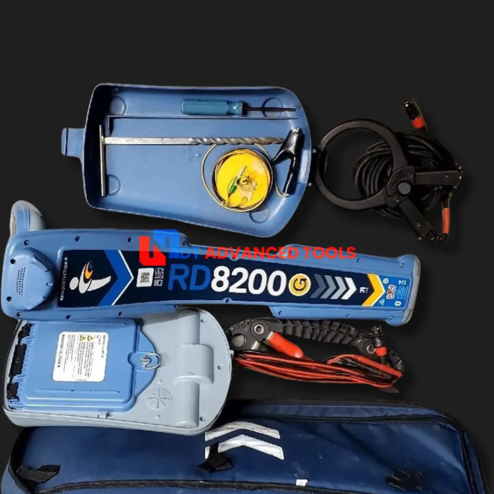
Radiodetection SPX RD8200 Cable Pipe Locator TX-10B Transmitter
Sale used Radiodetection SPX RD8200 Cable Pipe Locator with T-10B Signal Transmitters. In working conditions, come with 3 Months warranty and 30 Days money back guarantee
Condition: Used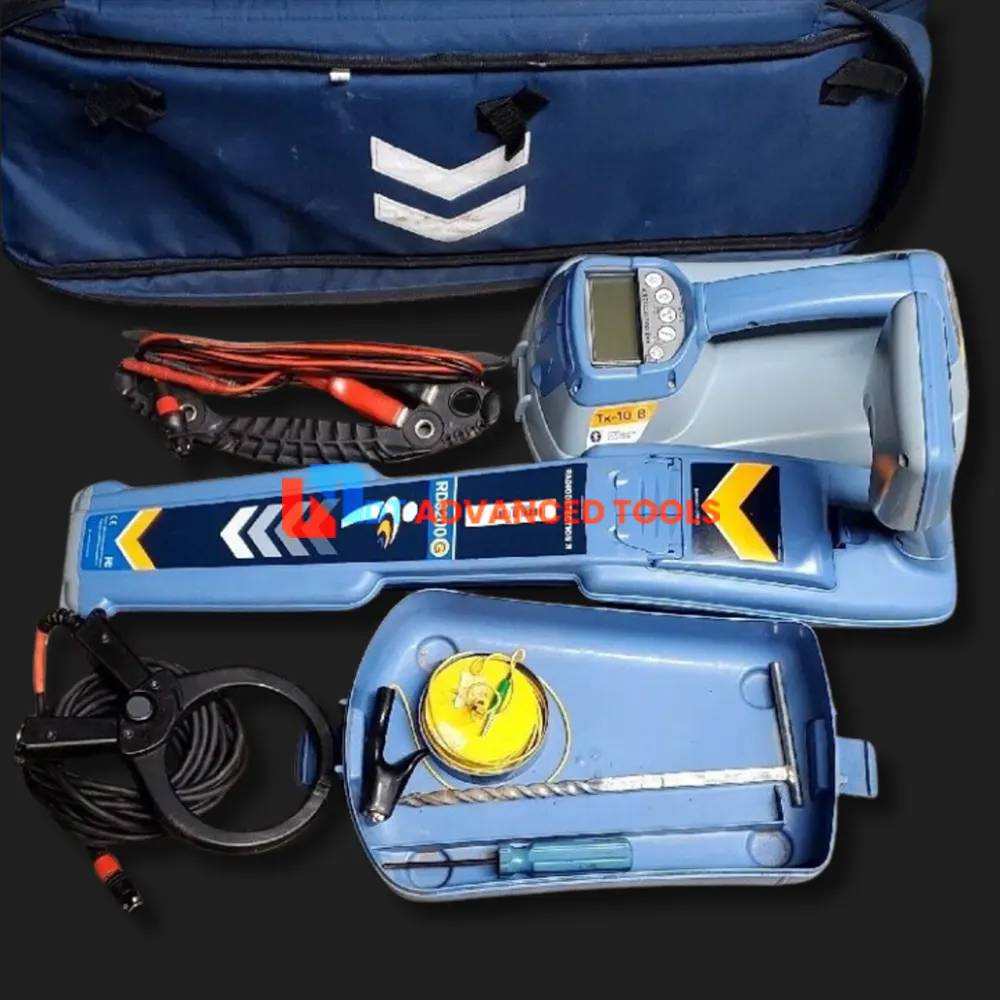
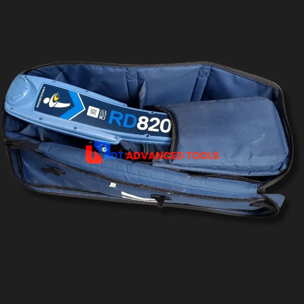
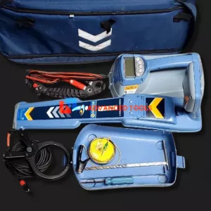
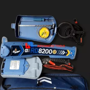
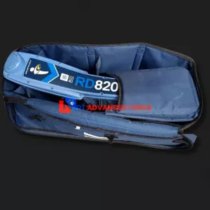
Sale Spx Radiodetection RD8200 T10B Cable Pipe Utility Locator. In working conditions, come with 3 Months warranty and 30 Days money back guarantee
Package includes:
- RD8200 Pipe Locator
- Lithium-Ion battery packs for RD8200
- Lithium-Ion battery chargers
- Transmitter Clamp
- Earth Reel
- Earth Stake
- TX-10B Transmitter
- Lithium-Ion Battery for TX-10B
- Automotive Power Lead
- Direct Connection Lead
- Transportation and storage accessories
SPX RD8200 Specifications
| Product Summary | |||||||||||||||||||
| Product Descriptions |
|
||||||||||||||||||
| Intended Use |
|
||||||||||||||||||
| Standard Equipment |
|
||||||||||||||||||
| Performance | |||||||||||||||||||
| Sensitivity | 6E-15 Tesla 5µA at 1 meter (33kHz) |
||||||||||||||||||
| Dynamic range | 140dB rms/√Hz | ||||||||||||||||||
| Selectivity | 120dB/Hz | ||||||||||||||||||
| Depth measurement precision | ± 3% | ||||||||||||||||||
| Locate accuracy | ± 5% of depth | ||||||||||||||||||
| Active Locate filter bandwidth | ± 3Hz, 0 < 1kHz ± 10Hz, ≥ 1kHz |
||||||||||||||||||
| Start-up time | <1 second | ||||||||||||||||||
| Maximum depth readout |
|
||||||||||||||||||
| Locate Functions | |||||||||||||||||||
| Active Locate Modes |
|
||||||||||||||||||
| Gain control |
|
||||||||||||||||||
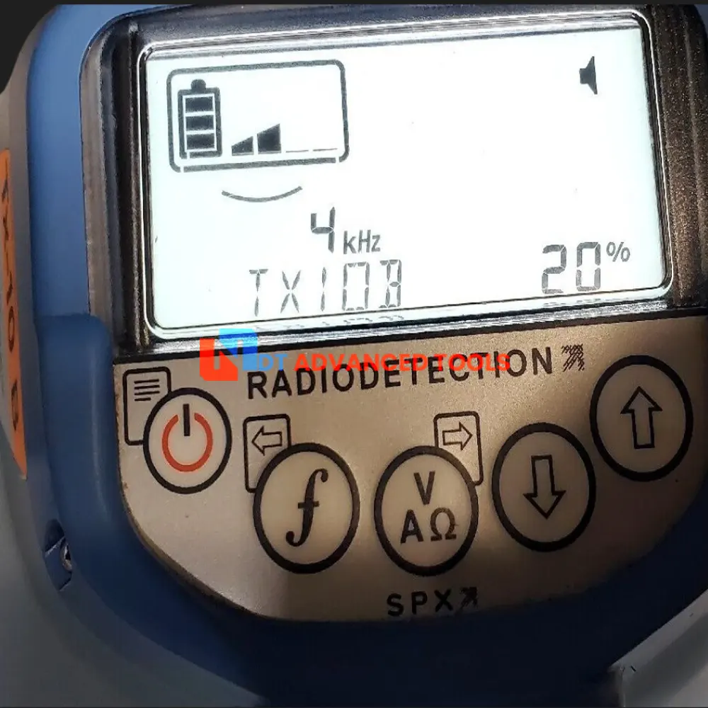
| Custom locate frequencies | Up to 5 additional frequencies in the range 50Hz to 1kHz at 1Hz resolution | ||||||||||||||||||
| Active locate frequencies | 21 Frequencies: ELF (98/128Hz), 512Hz, 570Hz, 577Hz, 640Hz, 760Hz, 870Hz, 920Hz, 940Hz, 1090Hz, 1450Hz, 4096Hz, 8kHz, 8440Hz, 9820Hz, 33kHz, 65kHz, 82kHz, 83kHz, 131kHz and 200kHz | ||||||||||||||||||
| Sonde Frequencies | 4 Frequencies: 512Hz, 640Hz, 8kHz and 33kHz7 | ||||||||||||||||||
| Fault Find | 8KFF and CDFF Locate insulation sheath faults on pipes and cables to 10cm / 4” accuracy using the accessory A-Frame and a compatible transmitter |
||||||||||||||||||
| Current Direction™ (CD) Signal Pairs | Confirm operator is following the target pipe or cable with CD arrows and a compatible transmitter
14 CD Pairs: 219.9/439.8Hz, 256/512Hz, 280/560Hz, 285/570Hz, 320/640Hz, 380/760Hz, 460/920Hz, 4096/8192Hz, 680/340Hz (INV), 800/400Hz (INV), 920/460Hz (INV), 968/484Hz (INV), 1168/584Hz (INV), 1248/624Hz (INV) |
||||||||||||||||||
| Passive Locate Modes |
|
||||||||||||||||||
| Power Filters™ function | Switch out of sensitive Power Mode to locate on any of 5 individual mains harmonic frequencies:
|
||||||||||||||||||
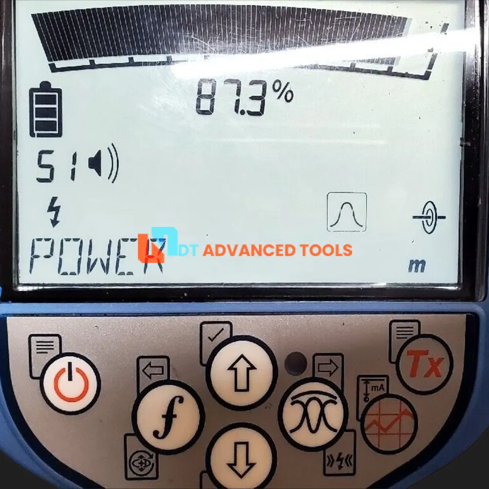
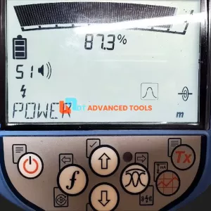
| Information displayed |
|
||||||||||||||||||
| Audio output tones |
|
||||||||||||||||||
| Accessory locate functions |
|
||||||||||||||||||
|
Locate Function Enhancements |
|||||||||||||||||||
| Strike Alert | Audio and visual warning when a cable or pipe less than 30cm deep is detected. Operates in Active and Passive locating modes | ||||||||||||||||||
| Haptic Vibration | Handle vibrates when StrikeAlert, Swing and Overload warnings activated | ||||||||||||||||||
| Swing Warning | Audio and visual warning when the user is swinging the locator excessively | ||||||||||||||||||
| Dynamic Overload Protection™ | 40dB, automatic: Automatically manages the system gain to compensate for strong signals e.g. from mains power or substations, to enable accurate locating | ||||||||||||||||||
| Overload warning | If the RD8200 becomes overloaded, users will be alerted by a flashing mode icon. Both the depth and current measurements will be disabled in the event of an overload. | ||||||||||||||||||
| Current Direction™ (CD) |
|
||||||||||||||||||
| iLOC™ |
|
||||||||||||||||||
| Side Step |
|
||||||||||||||||||
| Simultaneous depth and current readout | Both utility depth and locate signal current are displayed simultaneously, giving the operator more information to help them to follow the target utility | ||||||||||||||||||
| Survey Measurements |
|
||||||||||||||||||
| Fault Find | Apply a Fault Find signal with a Tx-5 and Tx-10 transmitter, then use an accessory A-Frame to detect and pinpoint insulation faults Fault find accuracy: Metric: 100mm Imperial: 4 |
||||||||||||||||||
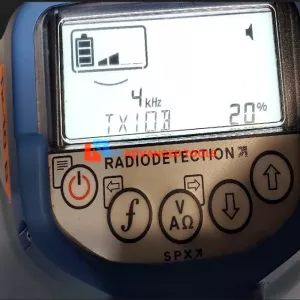
| 4.9 4kHz locate frequency and 4kHz CD |
|
||||||||||||||||||
| Peak+ mode | Use the accurate Peak bargraph, and add either proportional Guidance arrows for faster locating, or Null arrows to check for the presence of distortion | ||||||||||||||||||
| Integrated GPS option | Faster surveying using integrated GPS – no need for a separate hand-held device | ||||||||||||||||||
|
Configurability |
|||||||||||||||||||
| Option selection | All options can be enabled or disabled on the locator or using the RD Manager PC software | ||||||||||||||||||
| Languages supported | English, French, German, Dutch, Polish, Czech, Slovakian, Spanish, Portuguese, Swedish, Italian, Turkish, Russian, Hungarian | ||||||||||||||||||
| Mains power network options | 50 Hz or 60 Hz | ||||||||||||||||||
| Mode selection | All locate modes with the exception of Peak Mode can be individually enabled or disabled | ||||||||||||||||||
| Active frequency selection | All active frequencies available can be individually enabled or disabled | ||||||||||||||||||
| Passive mode selection | All passive modes can be individually enabled or disabled | ||||||||||||||||||
| Strike Alert | Enable / disable | ||||||||||||||||||
| Swing warning | Enable / disable | ||||||||||||||||||
| Haptic vibration | Enable / disable | ||||||||||||||||||
| Peak+ arrow selection |
|
||||||||||||||||||
| GNSS (‘GPS’) settings | Internal / External (connect over Bluetooth) / Off / Reset | ||||||||||||||||||
| iLOC Connectivity | On / Off | ||||||||||||||||||
| Data export protocols supported | PPP/choice of 3 ASCII formats. Optionally append positional data | ||||||||||||||||||
| Time / date setting | Correct or update locator real-time clock using the RD Manager PC software or GNSS signals | ||||||||||||||||||
| CD Reset | Reset CD phase analysis with a single long press of the frequency key | ||||||||||||||||||
| Audio | Set audio tone frequency level high or low | ||||||||||||||||||
| Connectivity | |||||||||||||||||||
| Wireless connections | Bluetooth 2.0 – SPP profile, class 1 Bluetooth Low Energy 5.0 |
||||||||||||||||||
| iLOC™ remote transmitter control range | Metric: Up to 450m Imperial: Up to 1400' |
||||||||||||||||||
| iLOC remote transmitter control functions |
|
||||||||||||||||||
| Wired connections Mini-USB |
|
||||||||||||||||||
|
Data capabilities and GNSS (‘GPS’) |
|||||||||||||||||||
| On-board GNSS (‘GPS’) option |
GNSS data automatically added to Survey Measurements every time locate data is saved, and every second on usage-logging data
|
||||||||||||||||||
| Link to external GNSS (‘GPS’) | Over Bluetooth: Connect to an external GNSS enabled device to combine survey measurements with that device’s GNSS data on the external device | ||||||||||||||||||
| External GNSS position read-in to locator memory | Connect to an external GNSS device to read positional positioning from that device and combine with the locator’s survey measurement data on board the locator | ||||||||||||||||||
| Survey measurement capacity | Up to 1,000 data records | ||||||||||||||||||
| Survey measurement data captured |
|
||||||||||||||||||
| Survey measurement export options via RD Map mobile app (Android only) | Bluetooth – ‘live,’ per measurement Bluetooth – batch export |
||||||||||||||||||
| Bluetooth survey measurement data protocol options | PPP ASCII (choice of 3 formats) Optional GPS data appended |
||||||||||||||||||
| Usage-logging memory | 4 GB | ||||||||||||||||||
| Usage-logging capacity | Over 500 days, measured at 8 hours use per day | ||||||||||||||||||
| Usage-logging capture rate | 1/ second | ||||||||||||||||||
| Usage parameters logged |
|
||||||||||||||||||
| Power options | |||||||||||||||||||
| Alkaline battery options | 2 x D-Cell (MN1300 / LR20) alkaline batteries (standard) | ||||||||||||||||||
| Rechargeable battery options | Custom Lithium-Ion (Li-Ion) battery pack 2 x D-Cell (MN1300 / LR20) Nickel Metal Hydride (NiMH) batteries |
||||||||||||||||||
| Battery run-time (continuous) | Li-Ion pack: 35 hours 2 x Alkaline D-Cells: 13 hours |
||||||||||||||||||
| Battery chemistry identification | Lithium-Ion pack: Automatic sensing NiMH / Alkaline: Software switchable |
||||||||||||||||||
| Charging options (Li-Ion pack) | Mains charger: 100-250 Volts AC, 50/60 Hz Automotive charger: 12-24V DC |
||||||||||||||||||
| Charging time (Li-Ion pack) | 3 hours to 80% from empty with maintenance trickle charging thereafter | ||||||||||||||||||
| Physical Characteristics | |||||||||||||||||||
| Design | Ergonomic, balanced and lightweight design for comfortable use during extended surveys | ||||||||||||||||||
| Construction | Injection Molded ABS Plastic | ||||||||||||||||||
| Weight | With Lithium-Ion battery pack fitted: Metric: 1.8kg Imperial: 4.0lb With D-cell alkaline batteries fitted: Metric: 1.9kg Imperial: 4.2lb |
||||||||||||||||||
| Ingress Protection rating | IP65 | ||||||||||||||||||
| Display type | High contrast custom made monochrome LCD | ||||||||||||||||||
| Audio options | Built-in waterproofed speaker 3.5mm headphone socket |
||||||||||||||||||
| Operating temperature | Metric: -20°C to 50°C Imperial: -4°F to 122°F |
||||||||||||||||||
| Storage temperature | Metric: -20°C to 70°C Imperial: -4°F to 158°F |
||||||||||||||||||
| Unit dimensions | Metric: 648 x 286 x 125 mm Imperial: 25.5 x 11.3 x 4.9 In |
||||||||||||||||||
|
RD Manager™ Online Supporting PC Software |
|||||||||||||||||||
| Operating System Compatibility | Microsoft® Windows® 10 64-bit | ||||||||||||||||||
| Functions |
|
||||||||||||||||||
| Data export formats |
|
||||||||||||||||||
| KML data export options | Filter usage-logging and survey measurement points on Google® maps. Select data to be tagged. Customize icon type / color, label type / color, line type / color |
||||||||||||||||||
| Certification and Compliance | |||||||||||||||||||
| Standards |
|
||||||||||||||||||
| European directives |
|
||||||||||||||||||
| Radio | FCC, IC | ||||||||||||||||||
| Environmental | WEEE compliant ROHS compliant |
||||||||||||||||||
| Manufacturing | ISO 9001:2008 | ||||||||||||||||||
| Third party certifications | Network Rail – Certificate of acceptance PA05/07424 | ||||||||||||||||||
Download:
Spx Radiodetection RD8200 T10B Cable Pipe Utility Locator Datasheet